
Alberta’s diverse landscape creates some of North America’s most compelling themed driving experiences. From the snow-capped peaks along the Continental Divide to the sun-baked hoodoos of the badlands, each route tells a distinct story through geography, history, and culture. Unlike random road trips, themed routes follow cohesive narratives—whether tracing pioneer heritage, conquering mountain passes, or exploring geological wonders—that transform ordinary driving into immersive journeys.
Planning a themed route requires understanding both the unique characteristics of each corridor and the practical realities of Alberta’s remote terrain. Distance between services, unpredictable weather patterns, and limited cellular connectivity demand preparation that casual travelers might overlook. This comprehensive resource examines Alberta’s signature themed routes while addressing the vehicle preparation, navigation strategies, and comfort considerations that ensure your journey is as rewarding as your destination.
Themed routes provide structure and purpose that elevate road travel from simple transportation to meaningful exploration. When you follow the Cowboy Trail southward along Highway 22, each ranch, historical marker, and small town reinforces the ranching heritage narrative. This coherent storyline helps travelers understand regional identity in ways that random stops cannot achieve.
The psychological benefits extend beyond education. Themed routes combat the monotony that leads to driver fatigue by creating anticipation for the next landmark. Research on long-distance driving shows that drivers remain more alert when navigating toward specific waypoints rather than enduring undifferentiated highway miles. A family heading to Horseshoe Canyon knows they’re building toward a geological payoff, maintaining engagement that benefits both driver focus and passenger patience.
From a practical standpoint, themed routes simplify decision-making. Instead of constant debates about where to stop or which direction to turn, the route’s theme provides natural filters. Heritage-focused travelers know to prioritize the Bar U Ranch National Historic Site, while geology enthusiasts target the Orkney Viewpoint. This clarity reduces travel stress and maximizes time spent on experiences that align with your interests.
The Icefields Parkway—Highway 93 North connecting Lake Louise to Jasper—represents perhaps the world’s most concentrated assemblage of alpine scenery accessible by paved road. This 232-kilometer corridor traverses ecosystems, climbs to the highest publicly accessible elevations in the province, and provides intimate encounters with glaciers, waterfalls, and wildlife that would otherwise require multi-day backcountry expeditions.
Mountain routes operate under constraints unfamiliar to prairie travelers. Seasonal road closures affect not just the Parkway itself, but access roads to many viewpoints and trailheads. The road to Peyto Lake’s main viewpoint typically closes in October and doesn’t reopen until June, meaning spring and fall travelers must settle for alternative vantage points or skip this iconic turquoise lake entirely.
Weather patterns shift dramatically with elevation. You might depart Canmore in sunshine and encounter snow squalls at the Columbia Icefield barely two hours later. Temperature drops of 15-20 degrees Celsius between valley and summit elevations are common. Experienced mountain travelers pack layers regardless of the season and monitor Parks Canada alerts for real-time road conditions, particularly during shoulder seasons when late spring snow or early fall storms create unpredictable situations.
Strategic route planning balances iconic stops with driving focus. The Weeping Wall—where groundwater seeps create spectacular ice formations in winter and cascading waterfalls in summer—requires only a brief pullout stop. Conversely, the Columbia Icefield Discovery Centre merits extended time for glacier tours and interpretive exhibits. Many travelers underestimate these timing differences and find themselves rushing through afternoon stops or driving after dark.
Peyto Lake accessibility illustrates the trade-offs inherent in mountain travel. The short trail to the viewpoint gains popularity precisely because it delivers stunning results for minimal effort, but summer crowds mean limited parking and congested viewpoints. Arriving before 9 AM or after 5 PM dramatically improves the experience, though this requires adjusting your overall route timeline.
Crossing the Continental Divide introduces physiological and mechanical considerations. Some visitors experience mild altitude effects—headaches, fatigue, or breathlessness—at elevations exceeding 2,000 meters. Staying hydrated and allowing time for acclimatization helps, particularly if you plan hiking from high-elevation trailheads.
Vehicle performance changes at altitude as engines receive less oxygen. While modern fuel-injected vehicles compensate automatically, older vehicles or those already struggling mechanically may lose noticeable power on steep grades. The combination of elevation, grade, and weather makes the Parkway challenging for oversized RVs, particularly when summer road construction narrows lanes or autumn snowfall reduces traction.
Highway 22 stretches nearly 700 kilometers from the Crowsnest Pass to Mayerthorpe, but the southern section between the US border and Calgary contains the densest concentration of ranching heritage and foothills scenery. This route exchanges mountain drama for rolling grasslands, historic ranches, and small communities where western heritage remains lived reality rather than tourist veneer.
The Bar U Ranch National Historic Site provides tangible connection to the ranching empires that shaped southern Alberta. Unlike museums presenting sanitized history, Bar U preserves working ranch buildings where you can observe the architectural solutions pioneers developed for harsh prairie winters. Timing your visit during interpretive programs allows interaction with costumed staff demonstrating traditional skills from blacksmithing to cattle handling.
Turner Valley’s oil history represents a different frontier narrative—the petroleum boom that transformed Alberta’s economy. The Turner Valley Gas Plant Historic Site preserves Canada’s first major oil and gas processing facility, offering guided tours that explain how this 1914 discovery launched the province’s energy industry. The industrial heritage complements rather than contradicts ranching history, showing how multiple resource economies coexisted in foothills communities.
Cowboy Trail culinary stops emphasize locally-sourced ingredients and regional specialties. Bragg Creek’s concentration of cafes and restaurants attracts weekend visitors from Calgary, offering everything from farm-to-table brunches to casual pubs featuring Alberta beef. Unlike highway truck stops designed for rapid refueling, these establishments encourage lingering—embracing the slower pace that themed routes deserve.
Planning culinary stops requires understanding service limitations. Many Highway 22 communities have limited dining options with restricted hours, particularly mid-week or off-season. Travelers accustomed to urban amenity density should research ahead rather than assuming options will appear when hunger strikes. Packing picnic supplies provides flexibility while supporting local producers at farmers’ markets and specialty shops along the route.
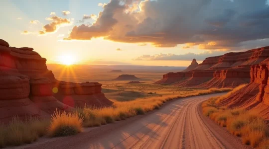
The Red Deer River valley carves through prairie benchlands to expose 75 million years of geological history in the form of layered badlands topography. The Drumheller region rewards travelers willing to navigate gravel roads and short hikes with viewpoints that transform abstract geological time into visceral visual experience. Unlike mountain routes following single corridors, the badlands demand loop configurations to access scattered viewpoints and canyon formations.
The Orkney Viewpoint provides panoramic introduction to badlands scale and color variation. Located northeast of Drumheller on a well-maintained gravel road, Orkney requires minimal walking but maximal observation time—the landscape’s subtleties emerge gradually as light shifts across eroded slopes throughout the day. Photographers favor golden hour when low sun accentuates ridge shadows and intensifies the rust, grey, and ochre color bands.
Horseshoe Canyon offers more intimate engagement through a short descent into the formations themselves. The trail switchbacks down to the canyon floor where you walk among hoodoos and examine the layered sedimentary rock at close range. Unlike roadside viewpoints, this hike provides scale context—standing beneath eroded pillars makes their formation process more comprehensible. The return climb gains approximately 60 meters, challenging for visitors unaccustomed to exertion but manageable with rest breaks.
Accessing Horsethief Canyon and several other prime badlands locations requires driving well-maintained gravel roads that nevertheless challenge urban drivers. Reduced speeds prevent windshield damage from flying stones—a legitimate concern that increases insurance claims for Drumheller-area travelers. Maintaining 60-70 km/h provides reasonable progress while minimizing rock chip risk, and increasing following distance protects against debris thrown by preceding vehicles.
Some loop variations involve crossing the Red Deer River on bridges that feel adventurous to flatland visitors. These crossings are safe and regularly maintained, but their narrow width and lack of shoulders create psychological discomfort for nervous drivers. Approaching at reduced speed and selecting times outside peak summer visitation reduces the likelihood of meeting opposing traffic mid-span.
Alberta’s themed routes traverse vast distances between services, transforming minor vehicle issues into major inconveniences. Preparation appropriate for urban errands proves inadequate when the next gas station lies 150 kilometers ahead or cellular service disappeared 40 kilometers back. Smart travelers adopt practices more common to backcountry enthusiasts than casual road-trippers.
The “half-tank rule” serves mountain and prairie travelers equally well: refuel whenever you reach half capacity rather than waiting for the low-fuel warning. This conservative approach accounts for detours, unexpected delays, and the reality that advertised services sometimes close temporarily. The Icefields Parkway has only one gas station—at Saskatchewan River Crossing—where fuel prices significantly exceed urban rates due to transportation costs. Filling completely in Lake Louise or Jasper reduces dependence on this expensive mid-route option.
Calculating range requires accounting for conditions that increase consumption. Mountain driving with frequent elevation changes, AC operation during summer heat, and headwinds on prairie routes all reduce the fuel efficiency your vehicle achieves during ideal conditions. Adding a 20% buffer to manufacturer estimates provides realistic planning parameters.
Remote route emergency kits expand beyond the basic triangle and first-aid supplies required by law. Practical additions include:
Windshield damage from gravel roads and rock debris represents the most common vehicle issue on Alberta routes. While you cannot prevent all chips, maintaining proper following distance and reducing speed on gravel minimizes risk. Addressing small chips promptly through mobile repair services prevents expansion into cracks requiring full windshield replacement.
Long-distance themed routes test patience and endurance for both drivers and passengers. The psychological dynamics of extended driving—boredom, fatigue, interpersonal tension from confined spaces—undermine even well-planned trips when wellness strategies are neglected.
Highway hypnosis—the trance-like state induced by monotonous driving conditions—affects even experienced drivers on Alberta’s long straight sections. The phenomenon becomes dangerous when reduced alertness delays reaction times during critical moments. Breaking driving into 2-hour maximum segments with active rest stops maintains sharpness better than enduring 4-5 hour marathons interrupted only by brief fuel stops.
Active rest means leaving the vehicle and moving your body, not just switching seats. A 10-minute walk through a small town or around a scenic pullout restores circulation and mental clarity. Some travelers combat fatigue by rotating drivers frequently, while solo drivers must build generous stop time into route planning rather than optimizing for maximum daily distance.
Entertaining kids on long drives requires age-appropriate strategies that balance screen time with landscape engagement. Younger children benefit from activity books themed to the route—wildlife spotting guides for mountain corridors, geology coloring books for badlands routes. Older kids and teens often engage more deeply when given research responsibilities: navigating to the next waypoint, reading interpretive information aloud at stops, or photographing journey highlights for later documentation.
Picnic logistics deserve advance planning since roadside facilities vary dramatically by route. Mountain parks provide developed picnic areas with tables and vault toilets, while prairie routes may offer only informal pullouts. Packing supplies in accessible containers—coolers in the back seat rather than buried under luggage—makes spontaneous stops feasible when scenic locations or hunger pangs arise unexpectedly.
Cellular service remains sporadic to non-existent throughout much of rural Alberta, with mountain valleys and remote prairie sections creating extended dead zones. Travelers accustomed to constant connectivity must adjust expectations and preparation methods. The Icefields Parkway provides virtually no reliable cell service between Lake Louise and Jasper—a reality that surprises visitors who assume coverage follows major highways.
Pre-downloading maps, route information, and accommodation details before departing urban areas prevents the frustration of trying to research options without internet access. Google Maps and similar apps allow offline map downloads for specific regions. Saving confirmation numbers, addresses, and phone numbers as photos or notes ensures access when you cannot retrieve emails or load websites.
The absence of connectivity offers unexpected benefits that many travelers discover retrospectively. Without constant notifications and browsing distractions, passengers engage more fully with landscapes and companions. Families report richer conversations and shared experiences when devices lose their competitive appeal. Embracing disconnection as feature rather than bug reframes the cell service limitation as opportunity for presence and mindfulness.
The philosophy underlying themed routes contradicts typical highway travel efficiency. Strategic time management for scenic routes means building generous buffers for spontaneous stops when unexpected vistas appear or intriguing small towns invite exploration. Rigid schedules that demand arriving at distant destinations by specific times undermine the journey-over-destination mindset that themed routes deserve.
Finding the best scenic pullouts combines research and spontaneity. Major viewpoints appear in guidebooks and online resources, but some of the most memorable stops emerge from noticing an interesting side road or elevation change suggesting views beyond the next ridge. Directional strategy matters—lighting conditions favor westbound mountain driving during morning hours and eastbound travel during late afternoon when sun illuminates rather than blinds.
Small town discoveries provide human connection that balances natural scenery. Communities like Bragg Creek, Longview, and Wayne offer glimpses of contemporary rural Alberta life distinct from historic sites presenting preserved pasts. Stopping at local museums, craft shops, or cafes supports these communities economically while enriching your understanding of how geography shapes culture. The best themed routes integrate landscape, history, and living communities into cohesive narratives that honor all three dimensions.
Alberta’s themed routes reward preparation with experiences that transform casual sightseeing into meaningful journeys. Whether navigating mountain passes, tracing heritage highways, or exploring geological wonders, success depends equally on understanding each route’s unique characteristics and preparing for the practical realities of remote travel. The investment in planning, vehicle preparation, and flexible scheduling pays dividends in safety, comfort, and depth of experience that distinguishes memorable adventures from forgettable trips.
The secret to the Dinosaur Trail isn’t driving two separate loops, but understanding it as a single figure-eight journey dictated by the Red Deer River. The “North” and “South” sections are just two halves of one continuous route, connected by…
Read more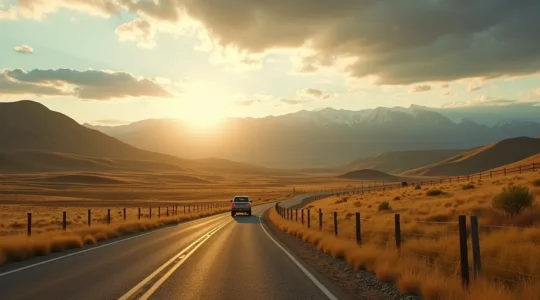
Choosing Highway 22 isn’t a detour; it’s a decision to experience an Alberta that the Queen Elizabeth II Highway completely bypasses. The Cowboy Trail transforms a simple drive into a journey through the province’s living history, from its ranching roots…
Read more
In summary: Treat the drive as a logistical mission, not a simple checklist, by applying strict time budgets to each stop. Drive from South to North (Banff/Lake Louise to Jasper) for safer, more efficient pullouts on your right-hand side. Mitigate…
Read more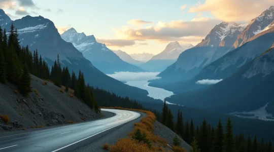
The greatest mistake on an Alberta road trip is believing the mountains are the only destination. The journey across the prairies and through the foothills is not an obstacle to overcome but a meditative experience that prepares you for the…
Read more
Successfully completing a 2,000km Alberta road trip depends less on your driving skill and more on preparing for the vast, empty spaces where help is hours away. Fuel, cell service, and even paved roads are not guaranteed between towns. Minor…
Read more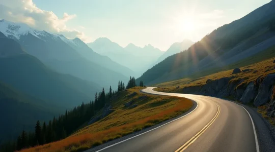
Navigating Highwood Pass safely is not about your driving skill, but your technical understanding of its unique, high-altitude environment. Weather is not random; it’s a predictable effect of elevation called orographic lift, which can cause sudden snow even in summer….
Read more