
Alberta’s geography defies the common perception of a uniform Canadian province. Within its borders, travelers encounter everything from towering mountain peaks exceeding 3,000 meters to desert-like badlands, from the world’s largest dark sky preserve to turquoise glacial lakes that seem chemically impossible. This dramatic variation in landscape creates fundamentally different travel experiences, each demanding its own preparation, timing, and understanding.
For visitors accustomed to more homogeneous destinations, Alberta presents a unique challenge: the skills and equipment that serve you well in the Canadian Rockies become nearly irrelevant in the prairie badlands just hours away. Understanding these territorial distinctions isn’t merely academic—it directly impacts your safety, comfort, and ability to access the province’s most remarkable natural features. This comprehensive overview breaks down Alberta’s major geographic regions, explaining what makes each area distinct and what that means for your journey.
The Canadian Rockies define Alberta’s western boundary, creating a 300-kilometer corridor of peaks, valleys, and alpine environments. For many visitors, this region represents their first encounter with serious elevation, and the physiological impacts catch people off guard more often than any other factor.
At elevations above 2,400 meters—common on many Alberta hiking trails and mountain passes—your body processes oxygen, fluids, and alcohol fundamentally differently than at sea level. Hydration needs increase by 50-100% compared to lowland environments, while alcohol tolerance can drop by half. What feels like moderate drinking at home can result in severe dehydration and impairment in the mountains. Physical preparation should begin weeks before your trip, focusing on cardiovascular conditioning rather than last-minute acclimatization attempts.
Alberta’s Rockies consist primarily of sedimentary rock formations—limestone, shale, and sandstone laid down in ancient seas. This matters practically: these rock types create distinctly different hiking surfaces than the granite found in other mountain ranges. Shale trails become slick and unstable when wet, while limestone can be sharp and abrasive to footwear. Understanding whether you’re hiking on shale or limestone directly influences your choice of boots, trekking poles, and route timing after rainfall.
Mountain weather in Alberta operates on its own timeline, independent of forecasts. Temperature swings of 20°C within a single afternoon are routine, and weather systems move through with startling speed. The layering approach that works here differs from coastal mountains: you need rapid moisture evacuation more than waterproofing, since precipitation often arrives as brief, intense bursts rather than sustained rain. A proper mountain layering system for Alberta includes a lightweight base layer, insulating mid-layer, and a wind-resistant shell that can be packed into a small space.
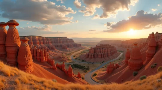
East of the foothills, Alberta’s landscape transforms into something visitors rarely expect in a northern province: semi-arid badlands with summer temperatures exceeding 35°C, venomous wildlife, and terrain that resembles Utah more than Canada. This region receives less than 400mm of annual precipitation, creating unique challenges for outdoor recreation.
The cognitive dissonance of extreme heat in Alberta throws many travelers off balance. Because people associate Canada with cold, they often arrive unprepared for desert-like conditions that persist from June through August. Hydration strategies must account for low humidity, which causes sweat to evaporate so quickly that people underestimate their fluid loss. The standard recommendation is one liter of water per hour of activity, but in the exposed badlands during summer, this should increase to 1.5 liters.
The prairie rattlesnake represents Alberta’s only venomous species, concentrated in the southeastern badlands and river valleys. Unlike dense forest environments where visibility is limited, the open terrain here allows for good sightlines—but rattlesnakes blend remarkably well with the grey-brown landscape. They’re most active during morning and evening hours in summer, when temperatures moderate. Practical avoidance involves watching where you place your hands during scrambling, never stepping over logs without looking, and making noise on trails, particularly near rock outcroppings.
The badlands present a unique photographic challenge: low-contrast landscapes where earth tones dominate. The famous hoodoos and layered sediments reveal their full drama only during specific light conditions—primarily the golden hour just after sunrise and before sunset. Midday light flattens the terrain into a monotonous beige, washing out the subtle color variations in the rock layers. Photographers should plan their schedules around these narrow windows, arriving at viewpoints 45 minutes before sunset for optimal positioning.
Alberta’s turquoise lakes—particularly in the mountain parks—have become iconic images, but the reality of visiting them involves more complexity than most photographs suggest. These water bodies result from glacial rock flour suspended in meltwater, creating their distinctive color while also presenting specific safety and timing challenges.
The vivid turquoise color that defines lakes like Moraine, Peyto, and Louise reaches maximum intensity during a narrow window, typically mid-July through early August. This timing corresponds with peak glacial melt, when the concentration of suspended particles hits its optimal level. Visit too early in the season, and the lakes appear more grey-green; too late, and sedimentation reduces the dramatic color. Water temperature and glacier melt rates also fluctuate year to year based on snowpack, making the timing less predictable than many visitors assume.
Glacial lake water temperatures rarely exceed 4-8°C, even during summer. This isn’t merely uncomfortable—it’s physiologically dangerous. Cold water shock can cause involuntary gasping and hyperventilation within seconds of immersion, while hypothermia begins affecting motor control within minutes. Swimming in these lakes requires understanding the difference between recreational swimming and brief, controlled immersion. Wetsuits designed for cold water (at least 5mm thickness) become essential for any extended water contact.
Many of Alberta’s most photographed lakes require either significant hiking effort or paid water experiences to access properly. Moraine Lake, for instance, now implements a reservation system during peak season due to parking limitations. On-water experiences—canoe rentals, boat tours, paddleboard access—typically range from $80-150 per person for a few hours. Lesser-known colored lakes exist throughout the Rockies, often requiring 5-10 kilometer hikes but offering similar visual rewards without the crowds or fees.
As Alberta’s northernmost major city, Edmonton functions as the gateway to the province’s remote regions while offering its own distinct urban character. The city’s festival calendar, winter infrastructure, and culinary scene reflect its role as a cultural hub in a challenging climate.
Edmonton hosts more festivals per capita than most Canadian cities, earning its “Festival City” designation. However, these events are heavily concentrated in the brief window between May and September, with some weeks featuring three or four simultaneous festivals. The Fringe Theatre Festival in August and the Folk Music Festival both draw crowds that impact accommodation availability citywide. Travelers should book lodging months in advance if visiting during these peak periods, or strategically plan visits during the shoulder weeks between major events for better rates and availability.
Edmonton’s winter survival systems offer lessons in cold-climate urban design. The city maintains an extensive pedway system connecting downtown buildings underground, allowing residents to move between offices, shops, and transit stations without outdoor exposure during the months when temperatures regularly drop below -25°C. For visitors, understanding this system transforms winter visits from endurance tests into comfortable experiences. The Ice Castles installation and river valley trail systems provide outdoor winter recreation options that embrace the climate rather than merely tolerating it.
This massive retail and entertainment complex remains both a tourist attraction and a point of confusion for visitors. With over 800 stores, an indoor water park, ice rink, and amusement park, the mall functions as a self-contained destination requiring its own planning. Most travelers either allocate a full day to experience the attractions or skip it entirely; there’s little middle ground. The attached hotel allows for multi-day immersion, though this appeals primarily to families with children rather than outdoor-focused travelers.
Canada’s largest national park—exceeding Switzerland in size—sits in Alberta’s remote northeast, straddling the provincial boundary with the Northwest Territories. Wood Buffalo represents true wilderness travel, where infrastructure is minimal and self-sufficiency becomes mandatory rather than optional.
Visiting Wood Buffalo differs fundamentally from accessing the mountain parks. There are no service towns nearby, limited cell coverage, and vast distances between points of interest. Fuel planning becomes critical—gas stations are separated by hundreds of kilometers. Most visitors allocate 4-7 days minimum for the journey, factoring in long driving stretches, basic camping infrastructure, and the need for complete self-sufficiency in food, water, and emergency supplies. Parks Canada recommends satellite communication devices for anyone venturing into the backcountry areas.
The park protects the world’s largest free-roaming bison population, with over 5,000 animals in herds that move across the landscape seasonally. These are wood bison, genetically distinct from plains bison, adapted to the boreal forest environment. However, visiting during the optimal wildlife viewing season (June-August) means confronting the park’s other defining feature: legendary insect populations. Black flies, mosquitoes, and horse flies reach densities that can make outdoor activities genuinely difficult without proper clothing and netting. Bug jackets with face nets transition from optional to essential equipment.
Wood Buffalo’s designation as a Dark Sky Preserve—the world’s largest—offers night sky viewing unmatched in accessibility elsewhere. With virtually no light pollution across its 44,000 square kilometers, the Milky Way appears three-dimensional, and meteor showers reveal faint shooting stars invisible near cities. The northern location also provides aurora viewing opportunities throughout the year, though the midnight sun during summer months limits the darkness window. Fall and early spring offer the best combination of aurora activity and true darkness, though temperatures and access difficulty increase significantly.
The Red Deer River valley around Drumheller contains one of the world’s richest dinosaur fossil beds, but this region’s appeal extends beyond paleontology to encompass unique desert-like terrain, dramatic erosional landscapes, and accessible outdoor experiences suitable for families with varying ability levels.
The terrain around Drumheller resembles a moonscape—deeply eroded, largely vegetation-free, and composed of easily crumbling sedimentary rock. “Popcorn rock” (bentonite clay) expands when wet and becomes dangerously slippery, creating a genuine fall hazard that injures visitors regularly. The local ecosystem supports minimal vegetation, with temperatures swinging from -30°C in winter to +35°C in summer. Camping in this environment requires understanding that shade is scarce, water sources are limited, and the terrain offers little natural shelter from wind or sun.
While fossils are abundant in the Drumheller area, collection rules are strict and often misunderstood. Finding fossils is common—you’ll likely spot bone fragments or petrified wood during any hike through the badlands. However, collecting vertebrate fossils (anything from an animal with a backbone) is illegal without permits. Plant fossils and invertebrate specimens can generally be collected in small quantities for personal use, but the regulations vary between provincial land, national parks, and private property. The Royal Tyrrell Museum offers fossil preparation programs where visitors can work on real specimens legally under supervision.
Drumheller has developed its infrastructure specifically for family visitation, but accommodation shortages during July and August create planning challenges. The town has fewer than 8,000 residents but receives over 400,000 annual visitors, mostly concentrated in summer months. Booking accommodations 3-6 months in advance becomes necessary for peak season visits. The Royal Tyrrell Museum serves as the anchor attraction, requiring 3-4 hours minimum for a meaningful visit. Families should arrive at opening time to avoid crowds, particularly during the summer holiday period when wait times for popular exhibits can extend to 30 minutes or more.
Alberta’s territorial diversity means that no single preparation strategy serves all regions. The mountain skills that keep you safe in the Rockies won’t help you in the badlands, and urban Edmonton requires completely different planning than remote Wood Buffalo. By understanding these regional distinctions—from glacial lake timing to desert heat management, from festival calendars to fossil regulations—you can tailor your approach to match each area’s specific demands. The province rewards those who recognize that traveling across Alberta means preparing for multiple destinations, not just one.
In summary: To avoid accommodation stress, book your stay 6-12 months in advance for summer, or consider nearby towns like Rosebud. Beat the crowds by visiting popular spots like the Little Church early in the morning or late in the…
Read more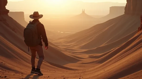
To survive a July hike in the Alberta Badlands, you must shift your mindset from a casual hiker to that of a paramedic preparing for a medical scenario. Heat safety is not just about drinking water; it’s a system of…
Read more
The grueling drive to Wood Buffalo isn’t a downside; it’s the very thing that protects its profound, untouched wilderness. You’ll encounter genetically unique bison found nowhere else on Earth and walk on glittering salt plains that look like another planet….
Read more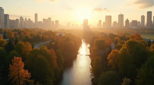
Edmonton is more than a list of attractions; it’s a living ecosystem where a northern spirit turns constraints like winter and isolation into celebrated cultural assets. The city’s soul is found not in curated experiences, but in grassroots festivals and…
Read more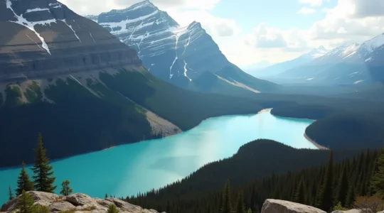
The iconic turquoise colour of Alberta’s lakes is not a static feature but a dynamic, living indicator of a glacier’s health and the physics of light itself. The colour is determined by the size and concentration of suspended “rock flour”…
Read more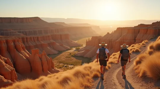
In summary: The Alberta Badlands present unique dangers in extreme heat that are unfamiliar to most visitors; generic summer advice is insufficient. Safety depends on understanding the specific behaviours of local wildlife (like rattlesnakes) and the properties of the landscape…
Read more
In summary: Flying from sea level to Banff (1,400m+) exposes your body to moderate hypoxia, a physiological stress many visitors underestimate. Generic advice like “drink water” is insufficient; prevention requires a structured acclimatization plan and understanding how altitude amplifies stressors…
Read more