
In summary:
- Identify “trimlines” on valley walls, which act as bathtub rings showing a glacier’s former height.
- Understand that the milky turquoise or emerald green colour of lakes is caused by “rock flour”—finely ground sediment from glacial erosion.
- Recognize the layered, castle-like appearance of mountains like Castle Mountain as a product of different rock types (limestone vs. shale) eroding at different rates.
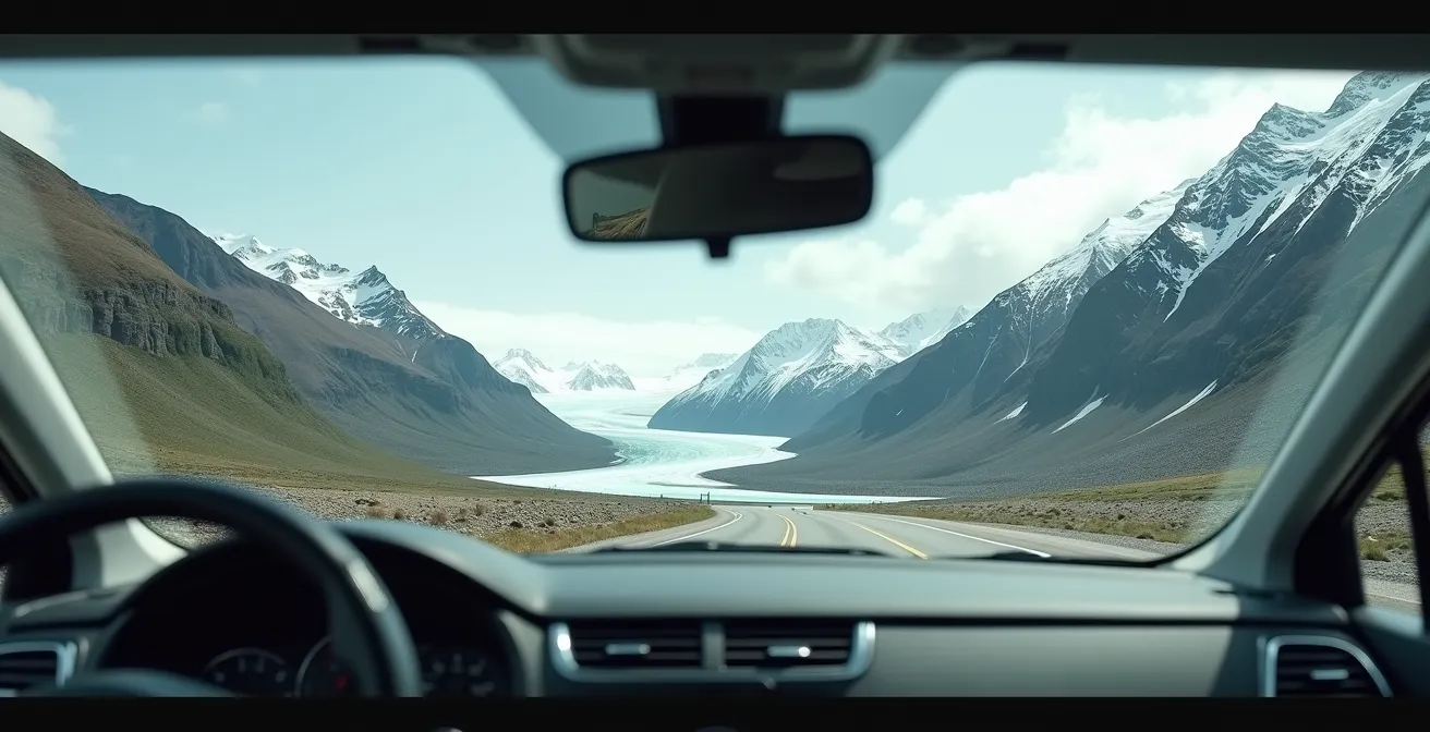
Driving the Icefields Parkway is an exercise in awe. Around every bend, another towering peak, impossibly blue lake, or vast, stony valley unfolds. It’s easy to feel small, a temporary visitor in a landscape of giants. But what if you could do more than just see it? What if you could read it? Many guides will give you a list of viewpoints, but they miss the real magic: understanding the story written on the land itself. You might look for the classic U-shaped valleys, but that’s just the first chapter.
This landscape wasn’t just placed here; it was carved, crushed, and sculpted by unimaginable forces, primarily rivers of ice. The key to a richer travel experience isn’t just knowing where to stop, but knowing what to look for when you get there. It’s about transforming your drive from a passive sightseeing tour into an active geological treasure hunt. Instead of just admiring the view, you’ll learn to spot the clues, decipher the evidence, and connect what you see today with a history stretching back millennia.
This guide moves beyond the obvious. We’ll explore the subtle signs of glacial retreat you can measure with your own eyes, the science behind the water’s mesmerizing colours, and the ancient human pathways hidden in plain sight. You’ll become a geological detective, using your car window as a lens into deep time. Prepare to see the familiar sights of the Banff to Jasper drive with a completely new perspective.
To help you navigate this geological story, this article breaks down the key evidence you can spot along your journey. Each section focuses on a specific question you might ask yourself while looking out the window, providing the tools to find the answer right in the landscape before you.
Summary: Reading the Glacial Story of the Icefields Parkway
- Why Is the Athabasca Glacier 1.5km Further Away Than in 1844?
- Found a Fossil? Why Moving It Ruining Its Scientific Value Forever
- Rock Flour Science: Why Are Some Lakes Blue and Others Emerald Green?
- Limestone or Shale: Which Rock Formation Created the famous “Castle Mountain”?
- Clovis Points: How Long Have Humans Actually Walked These Valleys?
- The Protected Zone vs The Wild: Where Can You Walk Near Hoodoos?
- How Much Has the Toe of the Glacier Receded Since Your Last Visit?
- Driving Banff to Jasper: How to Fit 10 Iconic Stops in One Day?
Why Is the Athabasca Glacier 1.5km Further Away Than in 1844?
When you stand at the toe of the Athabasca Glacier, it’s easy to be impressed by its sheer scale. Yet, what you’re seeing is a shadow of its former self. The question isn’t just *if* the glacier is smaller, but by how much, and how we know. The answer is written on the valley walls. As you look at the mountainsides flanking the glacier, you may notice a distinct line, like a bathtub ring. Below this line, a young forest grows. Above it, there’s only bare, weathered rock. This is a glacial trimline, and it marks the high-water mark of the ice during its last major advance, which peaked around the mid-1800s.
This visual evidence tells a dramatic story of retreat. Since the time of the earliest photographs and paintings, like those by artist Paul Kane in 1844, historical records show the Athabasca Glacier has receded by over 1.75 kilometres. The distance between the current toe and that historic trimline is a visible, measurable record of climate change. The process is ongoing; depending on the year’s conditions, the glacier can lose as much as 20 metres of horizontal ice annually. So, when you look at that bare rock high on the valley wall, you are time-traveling, seeing the ghost of a much larger, more powerful glacier.
Understanding this retreat transforms the glacier from a static landmark into a dynamic, changing system—a living (and shrinking) piece of Ice Age history.
Found a Fossil? Why Moving It Ruining Its Scientific Value Forever
The Rocky Mountains are built from ancient seabeds, uplifted and exposed. This means the ground beneath your feet is a treasure chest of fossils, from tiny shells to larger marine reptiles. It’s tempting, if you spot one, to pick it up as the ultimate souvenir. However, doing so destroys its most important feature: its context. A fossil’s location tells scientists about the environment it lived in, its age, and what other life existed at the same time. Removing it is like tearing a page out of a history book—the story is lost forever.
This principle is so critical that it’s protected by law in Alberta. As the experts at the Royal Tyrrell Museum, the province’s primary paleontological research centre, emphasize, a fossil’s scientific value is intrinsically tied to its location. As they state in their official guidelines:
If you find a fossil, the location is as important as the fossil itself. Photograph it and note any visible features (for scale, include a coin or pen).
– Royal Tyrrell Museum, Official fossil reporting guidelines
Ignoring this advice comes with severe consequences. Moving a fossil is a serious offense under Alberta’s Historical Resources Act, carrying potential fines of up to $50,000 and/or one year in prison. The message is clear: look, photograph, report, but do not touch. By leaving a fossil in place and reporting it, you become a partner in scientific discovery rather than an obstacle to it.
Your Action Plan: What to Do if You Find a Fossil in Alberta
- Do not excavate or remove the fossil – leave it in place.
- Photograph the fossil with a coin, pen, or another common object for scale.
- Note the exact location using your phone’s GPS coordinates or by referencing permanent landmarks.
- Report your find to the Royal Tyrrell Museum by emailing tyrrell.fossilreport@gov.ab.ca.
- Wait for expert assessment and instructions before taking any further action.
Your discovery could be a vital clue to Alberta’s deep past, but only if it remains part of the larger puzzle.
Rock Flour Science: Why Are Some Lakes Blue and Others Emerald Green?
The lakes along the Icefields Parkway—Peyto, Louise, Bow—are famous for their stunning, unnatural colours. They range from a milky, opaque turquoise to a deep, clear emerald. This isn’t due to pollution or minerals dissolved in the water, but to something suspended within it: rock flour. As a glacier moves, its immense weight grinds the bedrock beneath it into a fine powder, like cosmic sandpaper. This powder, with rock grains measuring between 0.002 and 0.00625 mm, is so light that it remains suspended in the meltwater that feeds these lakes.
The specific colour of a lake depends on the concentration and size of this rock flour. When light hits the water, these suspended particles absorb most colours of the spectrum but reflect the blues and greens, creating the vibrant hues we see. Lakes fed directly by a glacier, like Peyto Lake, receive a high concentration of rock flour, resulting in a milky, light turquoise colour. The fine particles scatter more of the light spectrum, making the water more opaque. Lakes further from their glacial source, like Lake Louise, allow more of the rock flour to settle out. With fewer suspended particles, the water becomes clearer and reflects a deeper emerald green.
This table breaks down the key differences using two of the parkway’s most iconic examples, a comparison that reveals how distance from a glacier acts as a natural filter.
| Lake Feature | Peyto Lake | Lake Louise |
|---|---|---|
| Typical Color | Milky Turquoise | Emerald Green |
| Rock Flour Concentration | Higher (closer to glacier) | Lower (more settled) |
| Glacier Distance | Direct glacial feed | Further from active glacier |
| Best Viewing Time | Mid-summer | Early summer |
| Water Clarity | More suspended particles | Clearer with depth |
So, the next time you’re standing at a viewpoint, you can act as a geological detective. The colour and clarity of the water are direct clues to the lake’s proximity to an active glacier and the powerful grinding forces at play, as detailed in analyses of glacial erosion processes.
Each lake becomes a unique expression of the same geological process, its colour a signature of its place in the landscape.
Limestone or Shale: Which Rock Formation Created the famous “Castle Mountain”?
Castle Mountain is one of the most distinctive landmarks on the drive, its fortress-like silhouette impossible to miss. Its unique shape isn’t an accident; it’s a perfect lesson in geology, visible right from Highway 1. The mountain is a “layer cake” of different rock types, primarily hard, resistant limestone and dolomite, alternating with soft, crumbly shale. During the formation of the Rocky Mountains, immense pressure from the west caused massive sheets of older rock to be pushed up and over younger rock layers—a process called a thrust fault. This is why, counter-intuitively, the older limestone layers of Castle Mountain sit on top of younger shale.
Erosion did the rest of the work. The hard limestone and dolomite layers form the vertical cliffs—the “walls” of the castle. The softer shale layers erode much faster, creating the sloped, vegetated ledges between the cliffs. This process, known as differential erosion, is what sculpts the turret-like battlements that give the mountain its name. From your car, you can clearly identify these alternating bands: the light-coloured, sheer cliffs are limestone, and the darker, gentler slopes between them are shale. You are looking at a masterclass in architectural erosion, where the strength and weakness of different materials have created a natural fortress over millions of years.
What appears at first as a single, solid mountain reveals itself to be a dynamic structure, shaped by a dramatic history of both immense pressure and slow decay.
Clovis Points: How Long Have Humans Actually Walked These Valleys?
While the glaciers are the primary architects of this landscape, they also played a crucial role in human history. As the colossal Cordilleran and Laurentide ice sheets began to retreat at the end of the last Ice Age, a path opened up between them. This “Ice-Free Corridor” is theorized to have been one of the first major migration routes for humans entering the Americas. The modern Icefields Parkway follows the approximate route of this ancient path. When you drive this road, you are tracing the footsteps of some of the continent’s earliest inhabitants.
This isn’t just a theory; it’s backed by archaeological evidence. Spear points, tools, and campsites have been discovered throughout these valleys, confirming a long and continuous human presence. In fact, archaeological work near the town of Banff, particularly around the Vermilion Lakes, has uncovered evidence of over 10,800 years of human encampments. These early peoples, often referred to as paleo-Indians, hunted now-extinct Ice Age megafauna like mammoths and giant bison. The Clovis points—distinctively fluted spearheads—found in the region are a hallmark of these ancient hunters.
This adds a profound human layer to the geological story. The same valleys carved by ice, which we now travel for recreation, were once critical corridors for survival. The viewpoints where we stop to take photos may well be the same strategic lookouts used by hunters thousands of years ago. The landscape is not just a geological marvel; it is an ancient homeland, a corridor of human history stretching back to the dawn of human presence in the Americas.
Every valley and pass holds not only the memory of ice but also the echoes of the people who followed in its wake.
The Protected Zone vs The Wild: Where Can You Walk Near Hoodoos?
Hoodoos are one of nature’s most whimsical creations—tall spires of rock capped with a harder, more resistant stone. They look like petrified giants or stone mushrooms. In Banff, you can see them from a designated trail near the Tunnel Mountain viewpoint. However, you’ll notice you can only view them from protected platforms. This is for a very good reason: Banff’s hoodoos are exceptionally fragile. They are formed not from solid sandstone, but from glacial till—a mix of gravel and silt left behind by glaciers and cemented together over time. A single touch or misplaced step can cause irreparable damage.
This strict, hands-off approach in Banff is best understood by comparing it to the more famous hoodoos in the Drumheller Badlands of southern Alberta. There, the hoodoos are carved from more durable sandstone and clay, and designated trails often allow for closer access. This difference in geology dictates the difference in access rules. As Alberta Parks makes clear in its regulations, the preservation of these features is paramount.
Do not cut, deface or remove any plant, fossil or rock. Removal or disturbance any fossil material is prohibited under the Historic Resources Act.
– Alberta Parks, Dinosaur Provincial Park Rules
This table highlights the crucial differences in geology and access, explaining why the rules are what they are.
| Location | Rock Type | Access Level | Viewing Distance |
|---|---|---|---|
| Banff Hoodoos Trail | Glacial till (cemented gravel) | Restricted – viewpoints only | Protected platforms |
| Drumheller Badlands | Sandstone and clay | Designated trails allow closer access | Can approach on marked trails |
| Formation Fragility | Extremely fragile | More durable but still protected | – |
| Protection Status | Strict enforcement | Provincial park rules apply | – |
The fences and platforms aren’t there to spoil your view; they are life support for these delicate geological wonders, ensuring they can be appreciated for generations to come.
How Much Has the Toe of the Glacier Receded Since Your Last Visit?
If you’ve visited the Athabasca Glacier before, you might notice it looks… different. A little smaller, a little farther away. This isn’t your imagination. The glacier’s retreat is not just a historical phenomenon; it’s a rapid, observable process happening year after year. While long-term data shows a retreat of over a kilometre since the 1800s, the recent acceleration is particularly stark. On average, the glacier’s toe is retreating at a rate of about 5 meters per year. Think about that: if you last visited five years ago, the edge of the ice could be 25 meters—the length of a swimming pool—further away than you remember.
Some years are worse than others. According to data tracking glacial retreat, the melt is speeding up, with some reports noting that 2023 experienced more ice melt than any of the previous ten years. This retreat isn’t just horizontal; the glacier is also thinning dramatically. This is called surface deflation. Since the 1960s, the glacier has not only retreated 600 metres but has also thinned by an average of 60 metres. In some places, the ice is over 100 metres thinner than it was just a few decades ago.
The markers at the “Toe of the Glacier” trail provide a powerful visualization of this. Each sign represents a point in time where the glacier’s edge once stood. Walking from the parking lot towards the current toe is a walk through time, with each step covering years of retreat. It makes the abstract concept of climate change tangible and personal. The distance you walk is a direct measure of the ice that has vanished.
It transforms a return visit into a scientific observation, connecting your own timeline to the much larger story of our changing planet.
Key Takeaways
- The landscape is a history book: U-shaped valleys, trimlines, and moraines are direct evidence of past glacial activity.
- Colour tells a story: The milky blue and green hues of alpine lakes are created by suspended rock flour, a byproduct of glacial grinding.
- Conservation is critical: Fragile formations like fossils and hoodoos derive their value from their context and must be left undisturbed for scientific and preservation reasons.
Driving Banff to Jasper: How to Fit 10 Iconic Stops in One Day?
Now that you have the tools to be a geological detective, the entire Icefields Parkway transforms into an interactive museum. To put your new skills into practice, a well-planned itinerary is essential. The drive itself is about 232 kilometres (144 miles) and takes roughly three hours without stops, but to truly experience the geological story, you need a full day. This itinerary focuses on 10 essential stops that progress logically from Banff to Jasper, each offering a unique chapter in the story of ice and rock.
Here is a suggested plan for a one-day geological tour:
- Vermillion Lakes (5 min from Banff): Start by observing ancient lake sediments and the broad, U-shaped valley that sets the stage for the entire drive.
- Johnston Canyon (25km): Witness the power of water carving through limestone, a preview of the erosional forces you’ll see all day.
- Lake Louise: A classic glacial lake. Observe its emerald colour and look for the Victoria Glacier that feeds it.
- Bow Lake: Fed by meltwater from the Bow Glacier, this is another chance to see active glacial processes at work.
- Peyto Lake Viewpoint: The ultimate spot to study rock flour. Notice its distinct milky turquoise colour, a sign of its direct glacial feed.
- Columbia Icefield Discovery Centre: The heart of the parkway. This is your base for understanding the massive icefield that is the source of so many of the park’s glaciers.
- Athabasca Glacier Viewpoint: See the glacier’s retreat markers and the trimlines on the valley walls.
- Sunwapta Falls: A powerful waterfall where the river takes a sharp turn, showcasing the erosive power of glacial meltwater.
- Athabasca Falls: Marvel at how water has carved a deep, narrow gorge through a thick layer of limestone.
- Jasper Townsite: Your journey ends in a valley defined by the confluence of the Athabasca and Miette rivers, a fitting conclusion to a day spent reading the language of water and ice.
A final pro-tip: to manage crowds, consider pairing a popular stop like Lake Louise with a quieter, nearby alternative for a different perspective. For example, after visiting the main lake, a short drive to Morant’s Curve offers classic Rocky Mountain views without the same density of people, allowing for more peaceful observation.
By transforming your drive into a purposeful exploration, you connect with the Canadian Rockies on a much deeper level, turning a beautiful road trip into an unforgettable educational adventure.