
The secret to the Dinosaur Trail isn’t driving two separate loops, but understanding it as a single figure-eight journey dictated by the Red Deer River.
- The “North” and “South” sections are just two halves of one continuous route, connected by the main bridges in Drumheller.
- The seasonal Bleriot Ferry is the critical variable; its status determines whether you can complete the northern part of the figure-eight or if you need a detour.
Recommendation: Before you start, check the Bleriot Ferry’s operational status and download offline maps for the entire area. This is the key to a smooth and confusion-free drive.
Visitors to Drumheller often arrive with a map and a point of confusion: the Dinosaur Trail. It’s presented as a “North Loop” and a “South Loop,” leading many to believe they are two distinct, separate drives. This is the first mistake. Trying to navigate it this way leads to backtracking, missed turns, and frustration, especially when you factor in the geography of the Red Deer River valley and its limited bridge crossings.
The key is to stop thinking in terms of two loops. As a local guide, I can tell you the trail is actually one continuous, 48-kilometre figure-eight. The centre of this “8” is the town of Drumheller itself, where the main bridges allow you to cross the river. The northern part of the route contains a second, crucial crossing: the Bleriot Ferry. Understanding this “river logic”—that the route is entirely shaped by where you can and cannot cross the water—is the secret to conquering the trail with confidence.
This guide will walk you through the trail not as a list of stops, but as a strategic drive. We’ll focus on the navigational choke points, the terrain you’ll encounter, and how to time your journey to see the Alberta Badlands at their most spectacular. Forget the confusing map; this is your practical, on-the-ground plan for driving the complete Dinosaur Trail.
This article provides a clear, step-by-step navigational strategy for your drive. Below is a summary of the key landmarks and crucial safety information we will cover to ensure you can explore the entire trail like a local.
Summary: A Step-by-Step Guide to the Dinosaur Trail
- High Above the River: Why is the Orkney Viewpoint a Must-See at Sunset?
- Down and Up: How Tough is the Hike Out of Horseshoe Canyon?
- Bleriot Ferry: What are the Operating Hours of this Free Ferry?
- Oysters and Thieves: What is the Legend Behind Horsethief Canyon?
- Gravel Road Safety: Can Your Rental Sedan Handle the Back Roads?
- Canoeing the Badlands: How to Paddle the Red Deer River Safely?
- Golden Hour or Blue Hour: When Do the Badlands Reveal Their True Colours?
- How Are Hoodoos Formed and Why Are They Disappearing?
High Above the River: Why is the Orkney Viewpoint a Must-See at Sunset?
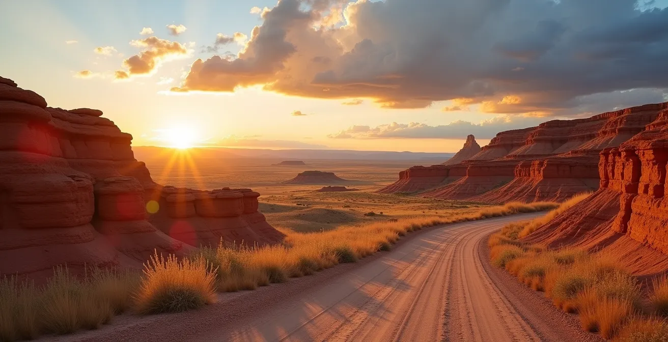
Perched on the rim of the Red Deer River valley, the Orkney Viewpoint offers more than just a pretty picture; it provides a profound sense of scale and geographic understanding. From this vantage point, you can see the river snaking through the valley, physically dividing the landscape. It’s here that the “river logic” of the Dinosaur Trail becomes visually apparent. You can trace the path of the roads on either side, grasping how the entire route is dictated by the water below. This perspective is invaluable before you descend into the valley itself.
But its strategic value is matched by its sheer beauty, especially at sunset. Thanks to Alberta’s vast, unobstructed prairie horizon, the ‘big sky’ phenomenon creates exceptionally long and vibrant sunsets. The light doesn’t just fade; it lingers, painting the canyon walls in shifting shades of orange, red, and purple. This extended golden hour provides a unique opportunity for photographers and sightseers alike to witness the Badlands in their most dramatic light. Arriving just before sunset allows you to watch the shadows lengthen and the colours deepen across the patchwork of farmland and canyon land below.
To make the most of the experience, a little planning goes a long way. The main platform can get crowded, so arriving early lets you find a better composition. For photographers, this is the time to set up for a truly memorable shot.
- Arrive 30 minutes before sunset to scout composition spots away from the main platform.
- Use a polarizing filter to cut through any afternoon prairie haze and enhance the deep colours of the canyon.
- Set up a tripod for long exposures as the light fades, allowing you to capture the movement in the clouds against the static landscape.
- For the best angle on the sunlit canyon walls, position yourself on the east side of the viewpoint.
As dusk settles, you might also spot wildlife like deer or coyotes becoming active in the valley below, adding a final, magical touch to the experience.
Down and Up: How Tough is the Hike Out of Horseshoe Canyon?
Horseshoe Canyon plunges you directly into the heart of the Badlands landscape. Unlike the drive-up viewpoints, this stop invites you to descend into the maze of coulees and hills. The hike itself isn’t a marathon, but its toughness is deceptive. While the official trail is moderately rated, the real challenge isn’t the distance or elevation; it’s the ground beneath your feet. The canyon is carved from layers of sandstone and bentonite clay, a substance that becomes incredibly slick and slippery when even slightly damp.
Even in dry conditions, navigating the steep sections with loose gravel and clay requires concentration and proper footwear. A simple pair of running shoes won’t provide the grip needed; sturdy hiking boots are essential for both safety and confidence. Many visitors underestimate the terrain and find the climb back out more strenuous than they anticipated, especially under the hot summer sun with little to no shade.
This introductory paragraph explains the complex challenge of the terrain. To fully grasp it, consider the visual evidence of hikers navigating these unique slopes.

As you can see, the angle of descent combined with the loose surface makes careful footing paramount. For context on its difficulty relative to other popular Alberta hikes, the following comparison is useful. This data, from a regional analysis, highlights that the primary challenge at Horseshoe Canyon is technical terrain, not sheer endurance.
To put the hike into perspective, this table compares it with other well-known trails in Alberta, based on a recent comparative analysis.
| Trail | Difficulty | Elevation | Key Challenge |
|---|---|---|---|
| Horseshoe Canyon | Easy-Moderate | 30-40m | Loose bentonite clay when wet |
| Ha Ling Peak (Canmore) | Hard | 740m | Steep sustained climb |
| Johnston Canyon | Easy | 120m | Metal catwalks, minimal technical terrain |
Therefore, while the hike is accessible to most people with average fitness, it demands respect. Bring plenty of water, wear the right boots, and be prepared for the unique challenge of walking on ancient, and potentially treacherous, bentonite clay.
Bleriot Ferry: What are the Operating Hours of this Free Ferry?
The Bleriot Ferry is the single most important navigational point on the Dinosaur Trail. This small, cable-operated ferry is the only way to cross the Red Deer River on the northern portion of the route, and its operational status dictates your entire plan. It is not a 24/7 bridge; it’s a seasonal service with specific hours. According to provincial information, the ferry is typically operating from late April to November, with a capacity of 13 vehicles, but its operation is entirely dependent on river levels and weather. High water, ice, or high winds will shut it down without notice.
This is why a local’s first piece of advice is always: check the ferry status before you go. Relying on it being open without verification is the fastest way to a frustrating detour. The ferry itself is more than just a utility; it’s a piece of living history. Started in 1913 by Andre Bleriot, brother of the famous aviator Louis Bleriot, it’s one of Alberta’s last remaining cable ferries. Taking the 7-minute crossing is a trip back in time, a moment to pause, shut off your engine, and watch the Badlands drift by from the water’s perspective.
Because the ferry is such a critical variable, having a solid plan is non-negotiable. An audit of your driving plan can save you significant time and frustration on the road.
Your Dinosaur Trail Drive: A 5-Point Planning Audit
- Points of contact: Identify your key decision points on a map: the main bridges in Drumheller, the Bleriot Ferry crossing, and the start/end of the gravel road section (Township Road 304).
- Collecte: Inventory your resources before leaving. Ensure you have offline maps downloaded, the 511 Alberta website or phone number (1-403-710-9422) for ferry status, and your rental car policy details regarding gravel roads.
- Cohérence: Confront your plan with real-time variables. Check the weather forecast (for rain on bentonite trails) and the ferry’s operational status right before you depart.
- Mémorabilité/émotion: Prioritize your ‘must-see’ spots (e.g., sunset at Orkney, hiking Horseshoe Canyon) versus ‘nice-to-haves’ so you can adjust your schedule if the ferry is closed and your route changes.
- Plan d’intégration: Finalize your primary route (e.g., clockwise, starting south) and, most importantly, confirm your Plan B detour route in case the ferry is not running.
If the ferry is closed, you are not stranded. You must simply complete the “figure-eight” by backtracking and using the central bridges in Drumheller. The detour adds about 25-30 minutes but allows you to see all the sights on both sides of the river.
Oysters and Thieves: What is the Legend Behind Horsethief Canyon?
Horsethief Canyon offers one of the most breathtaking panoramic views along the Dinosaur Trail. But its name hints at a history far more intriguing than just pretty scenery. The legend is twofold, weaving together tales from the Wild West and from a time deep in prehistory. The more recent part of the name, “Horsethief,” comes from the late 19th and early 20th centuries. The canyon’s labyrinth of coulees and hiding spots made it an ideal place for horse rustlers to hide and rebrand stolen livestock before moving them on.
But the “oyster” part of the local lore goes back much further. It refers to the fossilized oyster beds found within the canyon walls. These are remnants of the Bearpaw Sea, a vast inland ocean that covered this part of Alberta about 75 million years ago. Walking through the canyon is like walking on an ancient seabed. This prehistoric marine environment created the perfect conditions for preserving the remains of the era’s dominant creatures. Dozens of dinosaur species have been found here, making it a hotbed for paleontological discovery.
Today, the canyon faces a modern version of the “thief” problem: fossil poaching. These paleontological treasures are protected by Alberta’s Heritage Act, and removing fossils from the area is illegal. The name now serves as a reminder of both its colourful human history and its immense scientific value. It’s a place where you can simultaneously imagine outlaws hiding in the coulees and Albertosaurs roaming the subtropical coastline that once existed here.
When you stand at the viewpoint, you’re not just looking at a canyon; you’re looking at a timeline stretching from the Cretaceous period to the era of cowboys, a story of oysters and thieves written in stone and legend.
Gravel Road Safety: Can Your Rental Sedan Handle the Back Roads?
This is one of the most common and practical questions from visitors: part of the Dinosaur Trail is unpaved. Specifically, the 15-kilometre stretch of Township Road 304 on the north side of the river, connecting to the Bleriot Ferry, is a gravel road. The good news is that, yes, a standard rental sedan can handle this section. You do not need a 4×4 or high-clearance SUV. However, you must drive differently than you do on pavement.
The primary feature of this road is “washboarding”—a surface of dense, parallel ripples that can severely reduce traction and control if driven too fast. The key to navigating it safely is to reduce your speed significantly, often to between 50-60 km/h. This allows your vehicle’s suspension to absorb the bumps rather than bounce over them. You’ll also want to increase your following distance dramatically to avoid windshield chips from stones kicked up by other cars.
The texture of the road is key. Visualizing the washboard surface helps in understanding why a change in driving style is necessary.
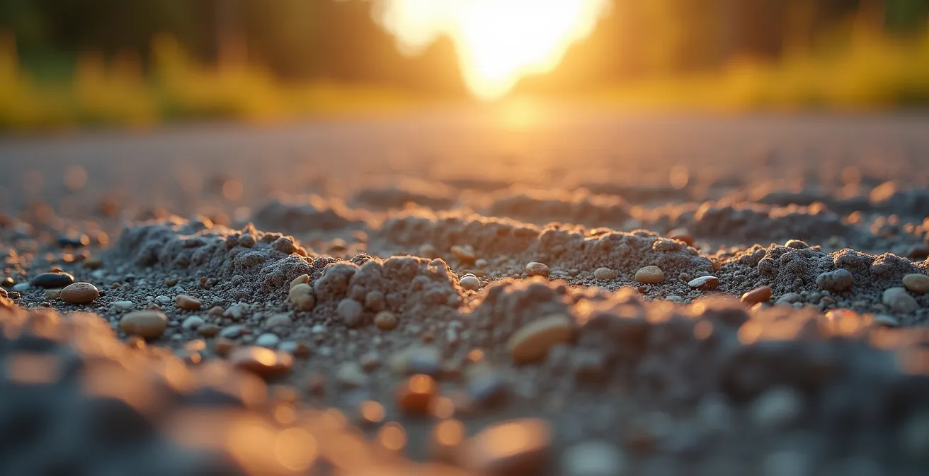
This close-up view shows the characteristic rippled pattern that demands a slower, more cautious approach. Another critical safety consideration is the lack of reliable cell service in much of the valley. It’s essential to have your route planned and maps downloaded for offline use before you leave Drumheller. Let someone know your travel plans, especially if you intend to hike in a more remote area off the main road.
Finally, a crucial tip for renters: check your rental car agreement. Some policies have clauses that void insurance coverage for damage incurred on unpaved roads. It’s better to be aware of your coverage before you start the journey. With these precautions, the gravel section becomes just another part of the adventure, not a source of anxiety.
Keeping your windows closed to minimize dust and taking it slow will ensure a safe and comfortable passage through this scenic, unpaved portion of the trail.
Canoeing the Badlands: How to Paddle the Red Deer River Safely?
While most visitors experience the Dinosaur Trail from the road, paddling the Red Deer River offers a completely different and intimate perspective. From the water, the scale of the valley and the intricate details of the canyon walls become much more apparent. The river here is generally slow-moving in the summer, making it accessible for novice paddlers and families. However, “slow” does not mean “without risk.” Safety on any Alberta waterway begins with the right gear and an understanding of the conditions.
As the river cuts through the Badlands, it deposits vast amounts of sediment. This process creates numerous hidden sandbars just below the surface, especially in late spring and summer as water levels drop. Running aground is a common occurrence. Be prepared for the possibility that you will have to get out of your canoe and pull it into deeper water. This is less an emergency and more a normal part of a Badlands river trip.
Before you even dip a paddle in the water, you must have the mandatory safety equipment required by Canadian law. This is not optional; it’s for your protection.
- A Canadian-approved Personal Flotation Device (PFD) or lifejacket for each paddler.
- A sound-signaling device, such as a whistle, often attached to your PFD.
- A 15-metre (50 ft) buoyant heaving line.
- A bailer or manual water pump to remove water from your craft.
Finally, always check the Alberta River Basins website for current flow rates and any advisories before you launch. River conditions can change quickly, especially in the spring when mountain snowmelt can lead to high, fast water suitable only for experienced paddlers. In late summer, the gentle flow is inviting, but vigilance for sandbars remains key.
Key Takeaways
- The Dinosaur Trail is a single 48-km figure-eight, not two separate loops. The town of Drumheller is the central crossing point.
- The Bleriot Ferry is the most critical variable. Always check its status (via 511 Alberta) before you drive the northern section.
- Proper footwear is essential for hiking in the canyons, as bentonite clay becomes extremely slippery when wet.
Golden Hour or Blue Hour: When Do the Badlands Reveal Their True Colours?
The light in the Alberta Badlands is a spectacle in itself. The unique topography and geology interact with the sun’s angle to create distinct periods of dramatic colour, but the best time to see them isn’t midday. The real magic happens during the “golden hour” and “blue hour.” According to local photography guides, the best lighting occurs from 30 minutes before sunset to 30 minutes after, a window where the landscape transforms completely.
The “golden hour” is the period shortly before sunset when the sun is low in the sky, casting a warm, soft, golden light. This is when the Badlands truly live up to their colourful reputation. This warm light accentuates the iron-rich sandstone layers in the canyon walls, making the reds, oranges, and yellows incredibly vibrant. The long shadows created by the low sun also add depth and texture to the landscape, defining the intricate shapes of the hoodoos and coulees.
As the sun dips below the horizon, the “blue hour” begins. This is a period of twilight when the sky is filled with a cool, deep blue light. This indirect, diffused light has a completely different effect on the geology. It highlights the cool tones in the landscape, particularly the greys and blues of the bentonite clay layers. While the golden hour is about warm, dramatic vibrancy, the blue hour is about cool, moody subtlety. It creates a serene and almost mysterious atmosphere, revealing a different personality of the Badlands.
So, which is better? Neither. They are two different acts in the same magnificent play. To truly experience the Badlands, try to catch both: witness the fiery spectacle of the golden hour, and then stay a little longer for the quiet, ethereal beauty of the blue hour.
How Are Hoodoos Formed and Why Are They Disappearing?
The hoodoos are the iconic emblems of the Alberta Badlands. These strange, mushroom-shaped sandstone pillars seem to defy gravity, standing as silent sentinels in the valley. Their formation is a slow, patient process of differential erosion spanning thousands of years. Each hoodoo consists of a soft sandstone base and a harder, more resistant capstone. Water, wind, and frost wear away the softer base more quickly than the protective capstone, gradually carving out the pillar shape over millennia.
However, these geological wonders are incredibly fragile. The same forces that create them are also actively destroying them. The sandstone is soft and crumbles easily. According to geological monitoring by Alberta Parks, the hoodoos face a significant 1-2 cm annual erosion rate. This process is accelerated by Alberta’s freeze-thaw cycles in the spring and fall, where water seeps into cracks, freezes, expands, and breaks off pieces of the rock. Every rainstorm and strong wind wears them down further.
Human interaction poses the most immediate threat. The oils from a single human touch can interfere with the natural erosion process and accelerate deterioration. Climbing on or near the hoodoos can cause irreparable damage in seconds. Because of this fragility, conservation is paramount. The main hoodoo viewing site has designated platforms and trails to protect these formations for future generations.
- Always stay on designated viewing platforms and marked trails.
- Never touch the hoodoos; even skin oils can cause damage.
- Report any vandalism or suspected fossil poaching to the Kananaskis Emergency Services at 1-800-642-3800.
- Use a telephoto lens for close-up photos instead of leaving the trail.
- Help educate others about the fines for violating the Provincial Parks Act by damaging natural features.
The hoodoos are a finite resource. They are a snapshot in geological time, and while new ones are technically always forming, the process is far too slow to replace the ones we lose. They are a powerful reminder of the slow, steady power of nature and our responsibility to be gentle guardians of these ancient stone figures.